- Published on
Danger Searching
- Authors

- Name
- agnik
Description
My friend told me that they hiked on a trail that had 4 warning signs at the trailhead: Hazardous cliff, falling rocks, flash flood, AND strong currents! Could you tell me where they went? They did hint that these signs were posted on a public hawaiian hiking trail.
Note: the intended location has all 4 signs in the same spot. It is 4 permanent distinct signs - not 4 warnings on one sign or on a whiteboard.
Note: Feel free to try multiple plus codes. The answer skews roughly one "plus code tile" south/west of where many people think it is.
Flag is the full 10 digit plus code containing the signs they are mentioning, (e.g.
lactf{85633HC3+9X}would be the flag for Bruin Bear Statue at UCLA). The plus code is in the URL when you select a location, or click the ^ at the bottom of the screen next to the short plus code to get the full length one. If your plus code contains 3 digits after the plus sign, zoom out and try selecting again.
Challenge Overview
The challenge involved locating a specific place based on hazard signs:
- Hazardous cliffs
- Falling rocks
- Flash floods
- Strong currents
Using a mix of Google Maps, Street View, and reverse image searching, I worked through the clues to find the correct location.
Step 1: Identifying a Possible Location
I started by checking out a hiking map for Kauai trails and noticed that the Kalalau Trail had multiple hazard signs. Given that this was one of the most dangerous trails in Hawaii, it seemed like a solid lead.
I then explored the area using Google Street View. One promising spot was at these coordinates: 22.220235, -159.58268. However, there were no strong current signs here, so I kept looking.
Step 2: Expanding the Search
I figured the location might be closer to a river or other water spot (requirement: strong current). Another possible spot I found was here, which also had some signs but not all of them.
Step 3: Reverse Image Searching
To speed things up, I Googled the exact phrase: "Hazardous cliff, falling rocks, flash flood, AND strong currents".
That led me to an Instagram photo showing a similar set of signs.
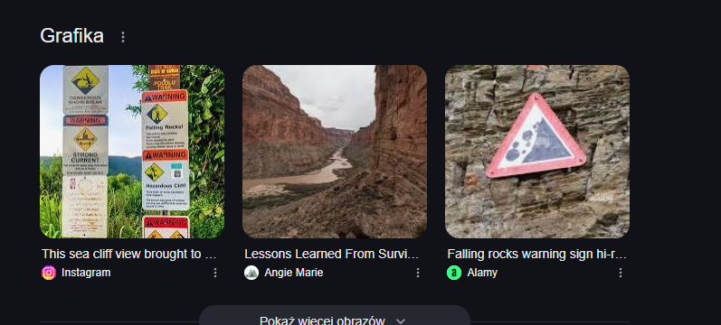
Running a reverse image search, I found that the location was near the Kohala Volcano. Another image confirmed it, but the problem was that one of the signs ("Flash Flood") was missing when I checked Street View, but one sign on photo was not visible - it was probably that this is the missing sign.

Google Street View presents signs in 2013. But on Bing there is another photo (from TripAdvisor) that presents this spot with all four signs present.
Step 4: The Final Answer
The location as mentioned in the description is near the answer square, the correct Plus Code for the answer was:
73G66738+9C
And here's the matching location in Bing Maps.
Final Thoughts
This challenge was a mix of OSINT, Google Maps detective work, and logic. The key takeaways were:
- Google Street View is great for verifying locations.
- Reverse image search helps when textual searches fail.
- Some old Google Street View photos (in this case photos from 2013) may not present the real situation (place without one sign worked as an answer).